
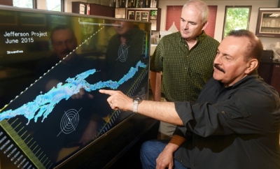
Lake George, New York, June 27, 2015: Here’s another way how the Internet of Things (IoT) combined with Big Data is being used to save the environment.
Scientists involved with the Jefferson Project at Lake George in New York, a research project that deploys Big Data and analytics technology to manage and protect a body of fresh water, said it was entering a new phase in which enormous amounts of data will be captured from sensors and analysed.
 The scientists anticipate that insights uncovered from the data collection and discovery stage of the project would not only help manage and protect one of America’s most famous lakes, but more importantly, create a blueprint to preserve important lakes, rivers and other bodies of fresh water around the globe.
By capturing and pooling data from all sorts of sensors, and analysing it, scientists said policy makers and environmental groups around the globe would soon be able to accurately predict how weather, contaminants, invasive species and other threats might affect a lake’s natural environment. Armed with these new insights and a growing body of best practices, corrective actions could be taken in advance to protect fresh water sources anywhere in the world.
A collaboration between IBM Research, Rensselaer Polytechnic Institute and The FUND for Lake George, the Jefferson Project involved over 60 scientists from around the world and IBM Research labs in Brazil, Ireland, Texas and New York. The project was deploying the IoT technology on a grand scale in conjunction with research and experimentation to understand the ecology of large lakes and the impact of human activity.
Thirty-five years of monitoring the chemistry and algae in Lake George by scientists at Rensselaer’s Darrin Fresh Water Institute, in collaboration with The FUND for Lake George, had demonstrated the lake’s features were changing. Chloride inputs from road salt had tripled, algae had increased by one third, and five invasive species had been introduced. These factors threatened entire regional economies driven by water recreation, boating and other forms of tourism on fresh water lakes, rivers and streams.
The new phase of the project was the culmination of several milestones. An array of sophisticated sensors of different shapes and sizes, including underwater sonar based sensors; customised software programs and solar energy systems to power off-grid equipment had now been deployed, tested and refined. These enhancements had led to greatly improved measurement data that would be used to better understand the lake and lead to improvements in the accuracy of four predictive models built by IBM researchers that precisely measured weather events, water run-off from the surrounding mountains into the lake, inputs of road salt to the lake, and water circulation.
New Jefferson Project milestones include:
- Using IBM’s Deep Thunder system, the weather model had improved its resolution with two-day forecasts now being made twice daily, with greater accuracy at more than half-mile intervals for precipitation; temperature; wind speed; wind chill and direction; humidity; visibility and more.
- The water run-off model, which maps the flow of precipitation and snow melt, now utilizes improved six-foot resolution topographical data of the lake’s watershed through the utilisation aircraft-based LiDAR surveying mapping technology.
- The salt model provides the first ever assessment of the relative amounts of road salt deposited in the lake from various segments of local roadways in the Lake George watershed. It identifies and compares more than six dozen locations around the lake where the application of salt to roads may cause the greatest contamination to the lake and surrounding area.
- The water circulation model had improved its resolution of the 200 foot deep lake, with new, high-resolution bathymetry from a recent hydrographic survey. The second generation model used 468 million depth measurements from the new survey — a vast improvement over the first generation model, which relied on only 564 depth measurements over the entire lake
“The Jefferson Project provides the unique opportunity for biologists and environmental scientists to work closely with engineers, physicists, computer scientists and meteorologists to understand large lakes at a level of detail and intensity that is simply unprecedented,” said Rick Relyea, Director of the Jefferson Project at Lake George.
“The world’s important bodies of fresh water such as Lake George are precious to people, essential to life and drive the economy, but they’re under siege from a growing list of threats,” said Harry Kolar, IBM Distinguished Engineer and Associate Director of the Jefferson Project. “The key to protecting this precious natural resource lies in the data, and the stage is now set to discover a deluge of insights about the delicate ecology of the lake and the factors that threaten it. The results of our efforts will help drive new ways to protect bodies of fresh water around the world.”
“Never in the history of any freshwater lake in the world has the caliber of science and technology now being brought to Lake George been applied for the purpose of sustaining lake health, ‘from physics to fish,'” said Eric Siy, Executive Director of The FUND for Lake George. “The empowered science of The Jefferson Project will empower people to ensure the Lake is protected for future generations.”
– Advertising Message –